
The six different cultural areas in Canada included...
-Arctic
-Subarctic (Western and Eastern)
-Plateau
-Great Plains/Prairie
-Northwest coast
-Wood lands or Northeast
Groups that lived in the same geographical areas would of had similar cultural elements, like diets, clothing styles, and housing. Below is a map showing these regions.

Cultural areas of North America Indigenous peoples at the time of European contact (2016) Uploaded by Nikater. Available online at: https://en.wikipedia.org/wiki/First_Nations#/media/File:Nordamerikanische_Kulturareale_en.png
During that time there were approximately 50 major language and 12 distinct language families in Canada, on top of that there were countless different dialects spoken by countless unique tribes. Language families are a group of languages that have evolved from one starting language. Although there were so many dialects, 94% of them are at risk of extinction. "As First Nations traditionally preserved and transmitted their culture and history through the oral tradition, no First Nations language in Canada had a writing system prior to European contact." (Quote from the University of British Colombia). It wasn't until the Europeans came over and taught them how did they start writing. Below is a map of the different language families.
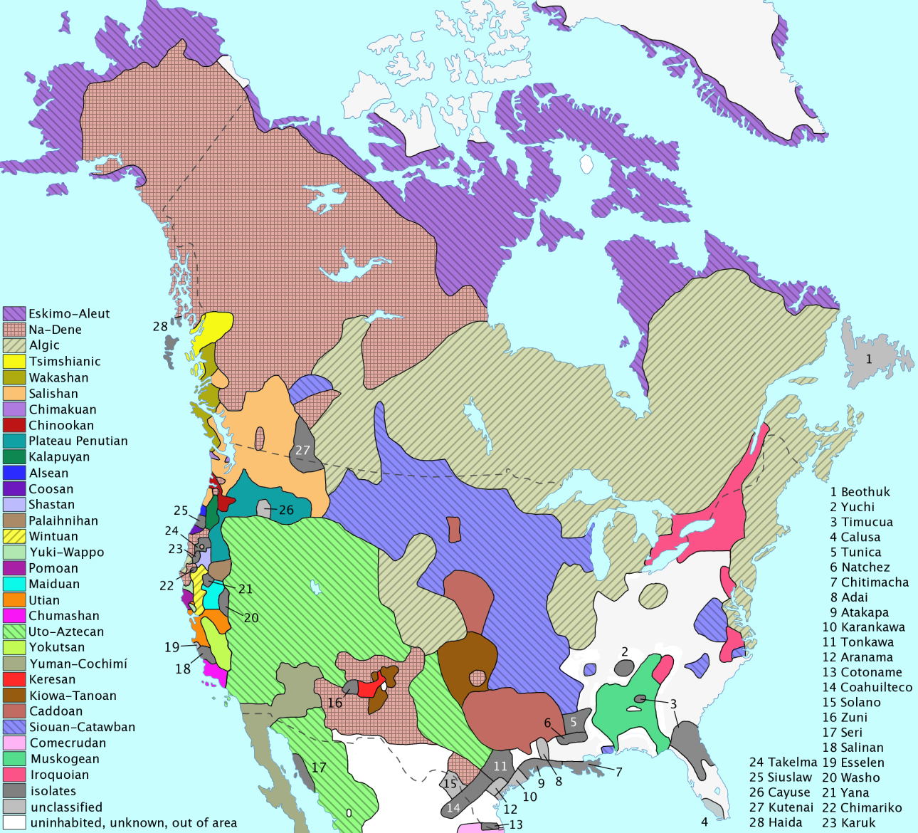
Distribution of language families and isolates north of Mexico at first contact (2016). Uploaded by en:User:ish ishwar. Available online at: https://commons.wikimedia.org/wiki/File:Langs_N.Amer.png
For more visit.
http://www.thecanadianencyclopedia.ca/en/article/aboriginal-people/ (used for first quote)
http://indigenousfoundations.arts.ubc.ca/home/culture/languages.html (used for second quote)
https://en.wikipedia.org/wiki/First_Nations
September.30, 2016
The map you included in this blog post was very helpful visually. It really adds a lot of colour and gives a visual example of all the areas. It's really sad to hear that 94% of the traditional dialects are at risk of extinction. It's quite crazy to imagine how they used to communicate back then. Considering there were about 50 different dialects that would have been probably difficult. It's quite cool to imagine what it would've been like for them, meeting and speaking slightly different versions of language. They were also very intelligent considering they even had language families. I also didn't know that there were actually 10 cultural groups that was a very neat fact. It’s quite amazing to imagine the way everyone would have been involved with each other, and how everyone would interact. I know it’s definitely not easy to communicate with someone who doesn’t speak the same language as you. The map is really cool because I can name the cultural areas that I live in and that I have been to. I live in the Western Subarctic, Plains, and woodlands. That is where Manitoba would be. (https://1eonsauce.wordpress.com/category/first-nations/ ). I like that you included information about the climate, that’s something very important. Another important thing that you included is the bit about clothing styles, and cultural elements. I had no idea that there was actually 12 different language families, I found that quite surprising actually. I figured there would be a lot less, just because they didn’t have books or paper or anything to actually write down their languages.
ReplyDeleteI really enjoyed reading your blog and studying the two maps that you included. the two maps are an excellent visual representation of where all of the cultural areas and language groups would have been in Canada and America. its cool to think that in Manitoba alone there were three cultural. areas and five language groups, I also didn't know that there were 10 different cultural areas in total. it sucks how 94 percent of the language groups are on the brink of extinction, maybe if the first people ha develop a written form of their language before the Europeans arrived perhaps we could have preserved some of them. I also didn't know that there where so many different language group through out Canada and north America. I thinks its a good thing that you also included that not everyone in different regions act, dressed and spoke the same way.
ReplyDeleteyou should take a look at this website (http://www.history.com/topics/native-american-history/native-american-cultures) it gives a detailed description of what the cultural areas where like.
Great post! I found this extremely helpful and very detailed. I enjoyed your maps very much. They were colourful and very showed me exactly where all the different cultural areas are. The fact that there were 3 different cultural areas in Manitoba alone, is shocking. The map of the language families is quite incredible! It’s amazing to think how many languages were spoken and how many different dialects there were. I was also very surprised by your quote from the University of British Colombia. The fact that there was no writing system in place is quite surprising. Europeans truly did bring many things over from their home countries. In Alexis’s comment she said how amazing it was how everyone interacted with each other even though they might not have spoken the same language and I agree! After the first initial contact, it would have been extremely difficult to explain who they were and how they got there! Is it heartbreaking how 94% of their languages are disappearing. Language is such an important part of any culture and to have such a huge part of your culture quickly disappearing is horrible. My only real critic is maybe next time you should include maps of only Canada’s cultural areas and language families so you can’t get confused because it is slightly difficult to guess where Canada ends and the United States begins but that’s just a nit-picky kind of thing. After reading some information on this website, I learned some quite interesting background history about the cultural areas, check it out at: (http://www.thecanadianencyclopedia.ca/en/article/aboriginal-people/).
ReplyDeleteI really enjoyed this post; the map you included in this blog post was very helpful visually. It really adds a lot of color and gives a visual example of all the areas. It's really sad to hear that 94% of the traditional dialects are at risk of extinction. It's quite crazy to imagine how they used to communicate back then. Considering there were about 50 different dialects that would have been probably difficult. It's quite cool to imagine what it would've been like for them, meeting and speaking slightly different versions of language. I really enjoy this post because it shows a lot of detail in the map, the languages and cultural areas are labelled really well in color bright and big to see. Check out this website that includes all of the detail about indigenous peoples and the charts, maps. http://www.thecanadianencyclopedia.ca/en/article/aboriginal-people/
ReplyDeleteyou did a really good blog post I think you probably could of added a little bit I don't know but other wise it was really good. the maps were really detailed but I had a really hard time reading it but all I have to say is good job.
ReplyDelete